Travel I-75
Project Highlights - ITS Edition
What are Intelligent Transportation Systems (ITS)?
Intelligent Transportation Systems (ITS) are advanced applications designed to provide innovative services relating to different modes of transport and traffic management. These systems enable users to be better informed and make safer, more coordinated, and ‘smarter’ use of transport networks.
Why add ITS Technology to I-75?
Improve Safety and Mobility through active traffic management with the ability to:
- Automatically detect incidents and respond faster
- Notify motorists about travel times, traffic queues, speeds and weather-related events.
- Notify motorist of adverse conditions through use of safety applications such as Curve Speed Warning and Bride Deck Warning Systems (read more about these systems below)
- Improve safety through the work zone through use of advanced connected vehicle applications
What type of ITS Technology is being implemented on I-75?
Closed Circuit Television Cameras (CCTV)
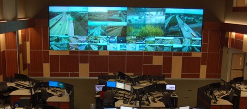 |
| Photograph: Southeast Michigan Traffic Operation Center (Detroit) Video Wall of the freeways |
What: CCTV’s are roadside video equipment installed on local roadways to monitor traffic conditions in real-time. Video is transmitted to the MDOT Traffic Operations Center (TOC) which is co-located with the Michigan State Police. These real-time videos are also accessible through the MiDrive site (https://mdotjboss.state.mi.us/MiDrive/map).
Where: CCTV cameras are mounted on tall poles every mile to achieve full coverage of the corridor.
Why/Benefits:
- Monitor traffic conditions in real-time
- Respond to incident faster
Vehicle Detectors
What: Vehicle Detectors are roadside equipment that use various sensor types to detect traffic conditions such as vehicle speed, volume, and lane occupancy.
Where: Installed every mile for full detection of the corridor.
Why/Benefits: Vehicle detectors are used in conjunction with other ITS devices to improve safety and mobility on the corridor. A typical ITS application is detection of traffic congestion. Information from the roadside detectors could be used by the traffic operators to post a warning message to the drivers on a dynamic message sign.
Dynamic Message Signs (DMS)
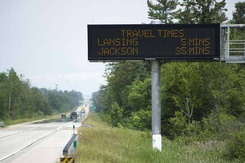 |
| Photograph: Sample DMS sign |
What: DMS are roadside equipment installed on MDOT freeways used primarily to provide traveler information to motorist .
Where: Installed at key locations throughout the corridor, usually a mile in advance of a major exit. DMS board messages are also accessible through the MiDrive site (https://mdotjboss.state.mi.us/MiDrive/map)
Why/Benefits:
- Ability to notify motorists about travel times, traffic queues, speeds and weather-related events.
- Improve traffic flow and mobility
Connected Vehicle
What: A connected vehicle can communicate bidirectionally with other systems inside and outside of the vehicle. Roadside wireless communication technologies are used to send safety messages to and receive messages from specific vehicles equipped with the required technology traveling in the detection range of the roadside units. Vehicle manufactures are currently testing this technology to make it available to the general public.
Where: Installed roadside at every mile, typically co-located with other ITS devices.
Why/Benefits: Multiple connected vehicle application development efforts and studies have demonstrated the potential for significant safety, mobility, and environmental benefits from the vehicle to infrastructure applications. The magnitude of the benefits depends on the level of technology deployment at the roadside, in vehicles, or within mobile devices. Example safety applications for the I‑75 corridor are listed below:
- Work Zone safety application uses information regarding work zone speed restrictions and lane closures to warn motorists of the need to reduce speed entering the zone.
- Curve Speed Warning application uses vehicle speed information to send a message to the driver depicting appropriate speed when approaching an upcoming curve.
Curve Warning Systems (CWS)
What: A curve warning system uses a combination of in-pavement or roadside sensors typically installed ahead of a curve to detect adverse traffic conditions and provide notification to drivers through use of warning signage.
Where: CWS are planned to be installed prior to key curve locations with known safety issues such as:
|
|
Why/Benefit: Assists drivers in avoiding crashes by warning the driver that the vehicle’s current speed may be too high to safely traverse one or more upcoming curves when an adverse weather condition is present.
Bridge Deck Warning Systems (BDWS)
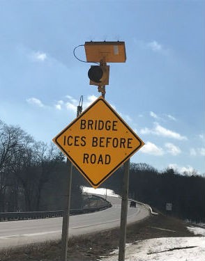 |
| Photograph: Sample BDW sign with flashing light |
What: A bridge deck warning system uses a combination of in-pavement or roadside sensors installed on the bridge deck to detect adverse weather conditions and provide notification to drivers to slow down through use of warning signage.
Where: BDWS was installed on I-75 SB at Square Lake Rd.
Why/Benefits: Assist in avoiding crashes by alerting the driver of icy or slippery pavement conditions on the bridge deck.
Environmental Sensor Stations (ESS)
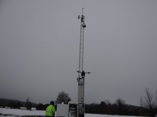 |
| Photograph: Sample ESS Installation |
What: An Environmental Sensor Station (ESS) is a fixed roadway location with one or more sensors measuring atmospheric, surface (i.e., pavement and soil), and/or hydrologic (i.e., water level) conditions.
Where: ESS are planned on
- I-75 at Goulson Ave
- I-75 SB at 12 Mile Rd
- I-75 SB at Square Lake Rd
Why/Benefit: Installed in key locations along the corridor to monitor weather conditions and provide roadway condition information to the TOC operators and MDOT maintenance forces. It also enhances the capability of the National Weather Service (NWS) to monitor the movement of large storms.
Fiber Optic Cable
What: Fiber optic cable is a high-speed communication media that uses pulses of light for data transmission.
Where: Fiber optic cable is being installed underground throughout the I-75 corridor.
Why/Benefits: To provide a fast and reliable communication network to the traffic operations center.
Additional Resources:
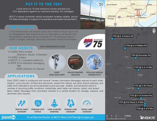
CAV Testing Programs - Come drive our 15-mile workzone corridor and test your CAV applications against our workzone advisory V2I messages.